
Via GRAPHIC PLUS | Quezon City (16 June 2026) — The Philippine Space Agency (PhilSA) is currently analyzing available satellite data on the 7.8-magnitude earthquake that struck the southern portion of Mindanao on June 8.
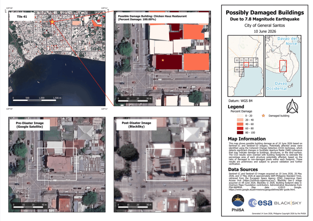
PhilSA produced maps showing damaged structures in General Santos City, with areas in red indicating changes to buildings, structures, or the land surface as of June 10, 2026. This was derived using change detection between Synthetic Aperture Radar (SAR) images from Sentinel-1C and Sentinel-1D satellites of the European Space Agency (ESA).
Post-event very high resolution (VHR) satellite images were able to capture specific buildings in General Santos City that sustained structural damage.
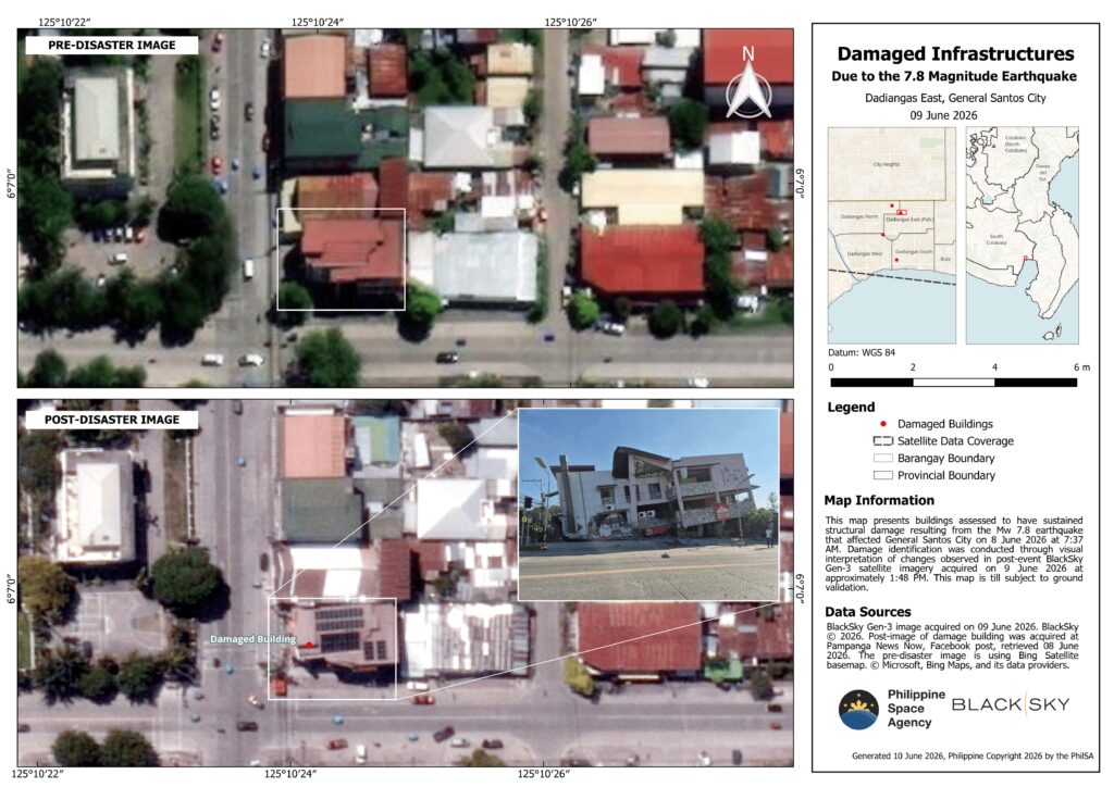
Overlaying the results of the SAR change detection analysis on the very high resolution (VHR) satellite images provides maps with high resolution and wide area coverage showing buildings in General Santos City that likely sustained the most damage. A subset of the data is shown in the map below, with likely damaged buildings in red. The maps are still subject to ground validation.
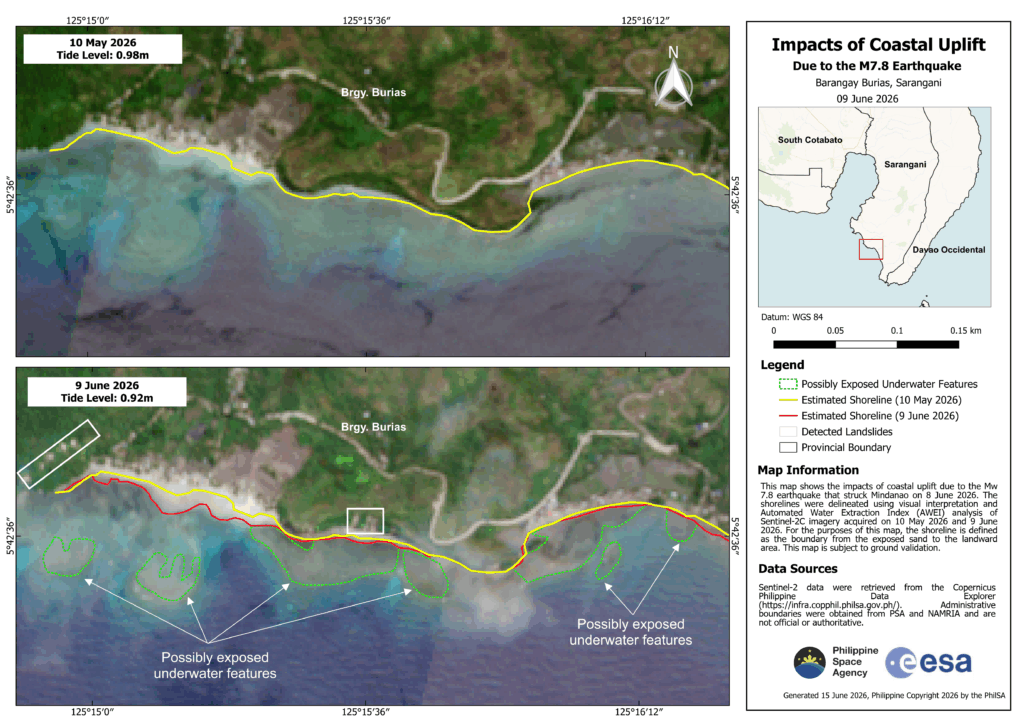
Coastal Uplift
PhilSA also generated maps showing shoreline shifts in Barangays Burias (shown below) and Pangyan, Sarangani, due to coastal uplift following the earthquake. In the maps, the shoreline (yellow pre-earthquake, red post-earthquake) is defined as the boundary of the exposed sand. Delineated in green are possibly exposed underwater features.
The shorelines were delineated using visual interpretation and Automated Water Extraction Index (AWEI) analysis of Sentinel-2C satellite imagery acquired on 10 May 2026 and 9 June 2026. The maps are subject to ground validation.
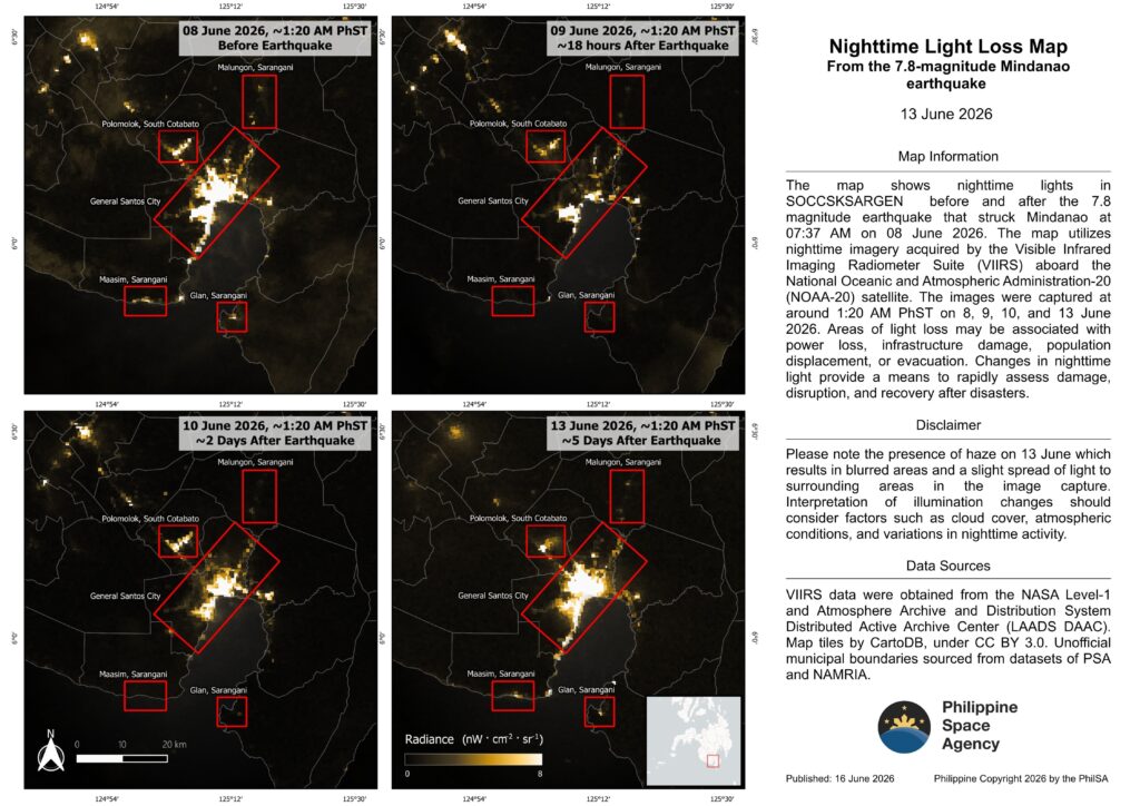
Return of Nighttime Lights
Changes in nighttime light provide a means to rapidly assess damage, disruption, and recovery after disasters. When lights go out, it often signals power loss, infrastructure damage, or population displacement/evacuation. PhilSA has been monitoring nighttime lights after the earthquake, observing a return of nighttime lights, which may be used as a proxy to monitor reconstruction and recovery
PhilSA’s support through the analysis of satellite data provides wide-area coverage that assists the National Disaster Risk Reduction and Management Council (NDRRMC) in monitoring the situation and prioritizing areas for response. By making space data accessible to stakeholders, PhilSA enables informed decision-making and strengthens disaster response.
PhilSA will continue monitoring satellite data as the situation requires. Please follow local and national agencies for the latest advisories.
Access the high-resolution maps here:
- Possibly damaged buildings: https://bit.ly/Earthquake_20260610_S1DBuildings
- Possible shoreline change due to coastal uplift: https://bit.ly/ShorelineShift_20260609_S2C